

Topocad Geometry
Standard shipping
Approximately 7-10 days delivery time
Geometry – Road
Topocad Geometry is an add-on module that requires the Topocad Basic Module.
(NOTE: Annual maintenance fee of 20% of the license value will be added starting next month)
Topocad's geometry format is a collection file for all different types of longitudinal geometry within Topocad. These are road line, profile, skew, cant and length table. Together they make up the entire longitudinal geometry for a roadway or a rail with cant. However, you cannot mix cant with skew, it is either or.
With Topocad Geometry you can import from a number of different formats, LandXML, the Geo files LIN and PRF, Geosecma road line (281) and rail cant (286), the DRD format DVL and DPL, Novapoints formats TIT and NYL and general import from ASCII files, such as Excel.
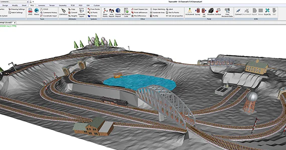
The geometry format, TGF, has a three-dimensional preview where you specify the desired width to reflect the design of the road or track. The TGF file can also be referenced to a Topocad drawing file.
Topocad's geometry module also includes Topocad's well-developed profile form, in which you can create profiles and illustrate different types of data in a profile. The profile form contains functions for creating and illustrating:
- profile lines and section markings
- terrain profiles, profile heights and terrain profile heights
- differences between profiles in distance and in graphical display
- skew information
- profile tangent points
- road line geometry
- area between selected profiles and terrain profiles
- corridor for the line from plan drawing and in profile drawing
All components can also be used an infinite number of times, so it is entirely possible to display information for several different profiles in the same form.
Both lines and profiles can be adjusted according to different methods and for the road line there is a built-in transformation calculation according to Gtrans, with an associated control and adjustment of the road line. Road lines can also be created and adjusted graphically in Topocad's road line editor.
In Topocad's geometry module you have a number of different functions for calculations from and against a geometry consisting of road lines and/or profiles. Calculation of section and side dimensions, or from section and side dimensions to coordinates and a surface control function all use the geometry format or standalone road and profile lines.
The module also contains a function for quickly creating a terrain profile and a function for creating a three-dimensional polyline in the drawing from a geometry line.
Topocad's geometry module also includes railway-specific functions such as cant and length table. Along with the special calculation functions available for railways such as rollover point calculation, bax and lift reports both from data in the drawing and directly from measurement data with export to bax/lift format ALC. There is also functionality to extract kilometers from a geometry with length table.
Geometry – Railway
Features
Here you will find the functions you need to work with railways. Typical functions for railways are rail cant and length tables in road lines and profiles, where you work with different kilometer lengths that are not 1000 meters. Other functions are wrap-around point calculation.
In addition, there is the calculation function bax/lift, which is a special function that generates both printed and graphical reports, and that reports bax and lift in a drawing.
The module also includes a FORMULA for reporting objects near rails.
Section templates for railway
We have adapted the section templates in Topocad for rail elevation in the Section Template module.
Topocad for Railway helps you measure and view your results in the best way! Topocad Railway was previously a separate module in Topocad but is now included in the Geometry module.
Sökord: