

Topocad Point Cloud
Standard shipping
Approximately 7-10 days delivery time
Topocad Point Cloud
Topocad Point Cloud is an add-on module that requires the Topocad Base Module.
(NOTE: Annual maintenance fee of 20% of the license value will be added starting next month)
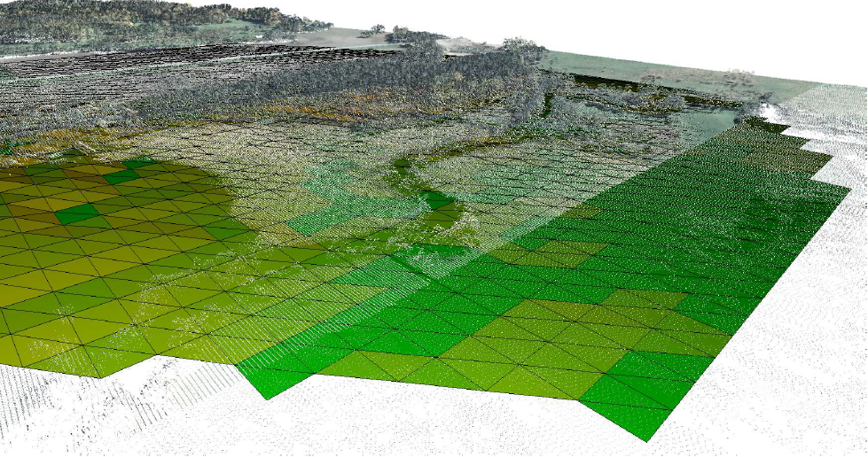
Topocad Point Cloud is an efficient module for using large point clouds. Topocad's point cloud module includes the ability to color point clouds from orthophotos or overlay a point cloud with a raster image.
File format
A number of file formats, including LAS/LAZ, NH (ESRI ASCII grid) and general ASCII files are imported into Topocad's TPC format. If there is RGBA information, i.e. colors and intensity, this can also be read. The point cloud can of course be viewed in 3D and if RGBA is used, the colors in the model are also visible.
Editing the point cloud
The point cloud can be edited manually. For example, selected points can be deleted. The point cloud can also be colored in different ways; by elevation, slope in the point cloud or by using a raster image. The point cloud can also be used to heighten a raster image. The Topocad point cloud file can then be used for a variety of functions. Among other things, it is possible to create a terrain model from the point cloud file for editing and use as a terrain model. The point cloud file can also be used directly in all commands that use a terrain model, including creating level curves, calculating volumes and creating terrain profiles.
Filter
The point cloud can be filtered with several types of filters:
- Noise filters are used to remove loose/unwanted points, for example points that are below the ground surface.
- Grid filter is a fast and good filter used to save a point according to a certain grid spacing. Choose highest, lowest or average value
- Ball filters are used, for example, to remove vegetation and maintain the ground surface
Export
Export of parts of (or the whole) point cloud can be done to different coordinate files or to Topocad point cloud files. It is also possible to import point clouds into Topocad drawing which gives the possibility to use the point clouds as references. The point cloud can be used as a background but also for snapping.
Identify cylinders in point clouds
The function finds all cylinders, large and small, in a point cloud. You set the parameters yourself: distance between points, max/min length and max diameter. The result is solids in a drawing where they can be edited.
Color a point cloud in comparison to a solid
so that it is easy to see where there are deviations, both inside and outside the solid. The function was developed for the Stockholm Bypass where the tunnel is designed with solids.
Sökord: Topocad, Punktmoln