Skip to content
GEOFIX NYA WEBBSHOP ÄR HÄR - klicka här för att få information om hur du som redan är Geofix kund kommer åt ditt webbkonto

PIX4D viDoc RTK

SKU viDoc RTK

Standard shipping

Approximately 7-10 days delivery time

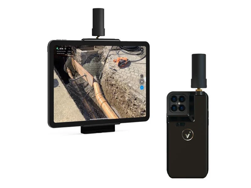
PIX4D viDoc RTK scanner

viDoc RTK scanner. Easy digitization with Pix4D software that can measure single points or create linework from data capture. Easy for anyone to collect points or perform an accurate 3D scan. The handheld scanner combines with mobile software to create digital twins as quickly as possible.

Catch

Use your smartphone with the PIX4Dcatch mobile app to capture the asset. Add an RTK device to it to improve your accuracy.

Process

Automatically upload your images to PIX4Dcloud for seamless processing OR import your images from your phone into the PIX4Dmatic desktop app using the PIX4Dcatch processing template.

Export to CAD/BIM/GIS

Mark your assets on PIX4Dsurvey as vectors in the point cloud and export them as DXF (for CAD) or SHP (for GIS).

Unleash the potential of RTK:

Accurate measurement from your mobile device

operational planning
Simple workflows from field to finish
Easy digitization with Pix4D software that can measure individual points or create linework from data collection.
operational planning
RTK positioning rover for 3D scanning
The viDoc RTK rover is paired with PIX4Dcatch to geotag images of the 3D scan in real time using NTRIP services.
document the project
Improved mobile data collection
viDoc connects to over 600 channels (including all major constellations such as GPS, GLONASS, Galileo, etc.) resulting in convergence in under 5 seconds.
Identify errors
Replace complex workflows
Land surveying equipment like laser scanners can be expensive, bulky, and highly technical. Drones can be restricted by regulations. Overcome the obstacles with a handheld rover.
resolve disputes
A complete, accurate workflow in your hands
ViDoc, the smartphone, PIX4Dcatch and PIX4Dcloud. A complete solution that gets measurements at the centimeter level, absolute accuracy.
Improve collaboration
Intuitive feel and structure
Easy for anyone to collect points or perform an accurate 3D scan, the handheld rover combines with mobile software to create digital twins as quickly as possible.

Sökord: